Trail  La Clusaz - 
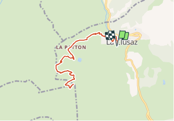
Pointe de Beauregard - Photo
 UDGI54
UDGI54

User

© OpenStreetMap contributors
Length
Length
9.9 km
Max alt
Max alt
1633 m
Uphill gradient
Uphill gradient
650 m
Km-Effort
Km-Effort  
18.6 km
Min alt
Min alt
1027 m
Downhill gradient
Downhill gradient
650 m
Boucle
Boucle
Yes
Creation date :
2022-01-10 23:12:19.562
Updated on :
2022-01-10 23:13:39.737

(0 Reviews)


Scan this QR Code to open this trail in the SityTrail application

FREE GPS app for hiking

Logo SityTrail SityTrail

IGN / Geographical institutes

Download SityTrail from the App Store Download SityTrail from Google Play

Logo SityTrail SityTrail Plus

The world is yours!

Download SityTrail from the App Store Download SityTrail from Google Play Download SityTrail on Huawei AppGallery

About

Trail of 9.9 km to be discovered at Auvergne-Rhône-Alpes, Upper Savoy, La Clusaz. This trail is proposed by UDGI54.

Description

Itinéraire assez court qui débute en forêt et se poursuit dans les alpages en traversant un hameau d’anciens chalets. Passage à proximité de la retenue d’eau de la Fériaz. Arrivée sur le Plateau de Beauregard.

Elevation profile

Positioning

Country:
France
Region :
Auvergne-Rhône-Alpes
Department/Province :
Upper Savoy
Municipality :
La Clusaz
Location:
Unknown
Start:(Dec)
Start:(UTM)
300049 ; 5086529 (32T) N.


Close
My subscriptions